


Descrizione di Cairn: Hiking & Outdoor Trail Safety
Cairn helps you get home safely from any outdoor adventure — hikes, runs, climbs, etc. Easily share your plans with loved ones, record your track, find spots with cell coverage, download maps for offline use, and see stats on your route.
Named one of the three best map apps for navigating the wilderness by Outside Magazine.
GET FOUND IF YOU’RE OVERDUE
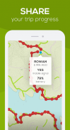
• Notifications: Safety contacts are notified when you’re past due
• Live tracking: Contacts can see your GPS location during your trip or hike
• Rescue advice: Contacts get important info needed to make intelligent rescue initiation decisions
STAY CONNECTED IN THE OUTDOORS
• Know where others have found cell coverage
• Download topo maps that are designed specifically for outdoor pursuits
SEE TRAIL STATS
• Get live distance, elevation gain and ETA stats for 4000+ hiking routes, summits, and trails worldwide
• Record and save your track
CAIRN IS
+ Easy: It only takes a minute to set up a Cairn
+ Open: Share plans with anyone – no app required to view
+ Flexible: Great for hiking, backpacking, trail running, horseback riding, skiing, cycling, rock climbing, camping, hunting, fishing, boating and more
Have feedback? Get in touch at adventure@cairnme.com.
Cairn ti aiuta a tornare a casa in sicurezza da qualsiasi avventura all'aperto: escursioni, corse, arrampicate, ecc. Condividi facilmente i tuoi piani con i tuoi cari, registra la tua traccia, trova luoghi con copertura cellulare, scarica mappe per l'uso offline e visualizza le statistiche sul tuo percorso.
Nominata una delle tre migliori app cartografiche per navigare nella natura selvaggia da Outside Magazine.
SCOPRI SE SEI IN ATTESA
• Notifiche: i contatti di sicurezza vengono avvisati quando è scaduto
• Monitoraggio in tempo reale: i contatti possono visualizzare la posizione GPS durante il viaggio o l'escursione
• Avviso di salvataggio: i contatti ottengono le informazioni importanti necessarie per prendere decisioni intelligenti sull'avvio del salvataggio
SOGGIORNO CONNESSO ALL'APERTO
• Sapere dove altri hanno trovato la copertura cellulare
• Scarica mappe topografiche progettate appositamente per attività all'aperto
VEDI LE STATISTICHE DEL PERCORSO
• Ottieni distanza in tempo reale, dislivello e statistiche ETA per oltre 4000 percorsi escursionistici, vette e sentieri in tutto il mondo
• Registra e salva la tua traccia
CAIRN È
+ Facile: ci vuole solo un minuto per installare un Cairn
+ Apri: condividi i piani con chiunque: nessuna app richiesta per la visualizzazione
+ Flessibile: ideale per escursionismo, zaino in spalla, trail running, equitazione, sci, ciclismo, arrampicata su roccia, campeggio, caccia, pesca, canottaggio e altro
Hai un feedback? Mettiti in contatto a adventure@cairnme.com.
Cairn: Hiking & Outdoor Trail Safety - Versione 1.3.8
(15-01-2024)Cairn: Hiking & Outdoor Trail Safety - Informazioni APK
Versione APK: 1.3.8Pacchetto: com.cairnapp.cairnApp nella stessa categoria
Potrebbe piacerti anche...


